Academic Training
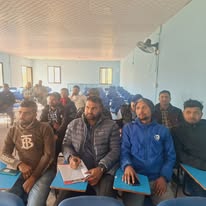
The short  course trainings are only focused on specific subject matter, so for in-depth knowledge of surveying, mapping, geo-information and land administration, long term trainings are conducted. LMTC has been conducting long-term trainings of 1 year duration for producing the skilled manpower in the sector of Surveying and Mapping, Geo-information and Land Administration. The long term trainings are also helpful for the up gradation of survey professionals. At present, the center has been providing Junior Survey Training Course and Senior Survey Training Course as long term training courses.
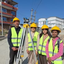
 The long term training courses are conducted on the Module basis in which each subject are dealt with in a time span of 3 to 4 weeks. These courses are delivered providing theoretical concepts, practical classes and labs, and field exercises which creates manpower with both theoretical knowledge and practicalities. The theoretical modules comprises of Introduction to Surveying & Geo-informatics, Mathematics & Physics, Computer Application & DBMS, Geodesy and Astronomy, Photogrammetry, Remote Sensing, Geographic Information System, Cartography, Cadastral Survey & Land Administration and Topographical and Engineering Survey. There are three to four field survey modules consisting of Conventional Survey, Geodetic Control and Cadastral Survey, and Engineering and Construction Survey Methods. Trainees are encouraged to perform project work and research activities on various geo-information techniques and land administration in the final independent project module. The projects and research are supervised and motivated by the instructors to encourage research practices.